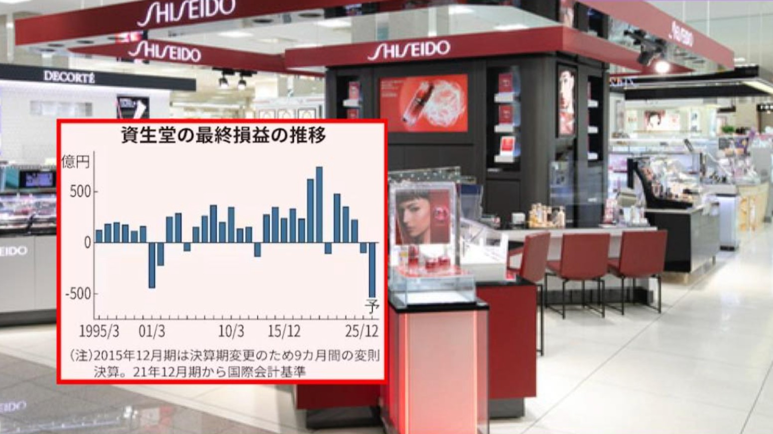
前線や
湿った
空気の
影響で
東日本と
西日本の
太平洋側を
中心に
大気の
状態が
非常に
不安定になっています。
Due to the influence of a front and moist air, the atmosphere is extremely unstable, especially on the Pacific side of eastern and western Japan.
関東では、10
日夕方から
夜のはじめごろにかけて
線状降水帯が
発生して
災害の
危険度が
急激に
高まる可能性があり、
気象庁が
警戒を
呼びかけています。
In the Kanto region, there is a possibility that a linear rainband will form from the evening to early night on the 10th, rapidly increasing the risk of disasters. The Japan Meteorological Agency is urging people to be on alert.
気象庁によりますと東北付近にある前線や暖かく湿った空気の影響で東日本と西日本の太平洋側を中心に大気の状態が非常に不安定になり関東北部などで雨雲が発達しています。
According to the Japan Meteorological Agency, due to a front near the Tohoku region and the influence of warm, moist air, the atmosphere is extremely unstable, especially along the Pacific side of eastern and western Japan, and rain clouds are developing in areas such as northern Kanto.
前線はこのあと南下する見込みで、日中の気温の上昇や上空の寒気の影響も加わるため、関東北部では、局地的に雷を伴って1時間に80ミリの猛烈な雨が降るおそれがあります。
The front is expected to move southward, and combined with the rise in daytime temperatures and the influence of cold air aloft, there is a risk of extremely heavy rain of up to 80 millimeters per hour accompanied by localized thunderstorms in the northern part of the Kanto region.
10日夕方から夜のはじめごろにかけては、茨城県と栃木県、群馬県、千葉県、東京23区と多摩地域、埼玉県で、線状降水帯が発生して災害の危険度が急激に高まる可能性があります。
From the evening to early night on the 10th, there is a possibility that a linear rainband will form in Ibaraki, Tochigi, Gunma, Chiba, the 23 wards of Tokyo and the Tama area, and Saitama, rapidly increasing the risk of disasters.
また、西日本の太平洋側などでも激しい雨が降るおそれがあり、11日昼までの24時間に降る雨の量は、いずれも多いところで関東甲信で200ミリ、九州南部で180ミリ、奄美地方で120ミリと予想されています。
Also, there is a risk of heavy rain on the Pacific side of western Japan and other areas. The amount of rainfall expected in the 24 hours until noon on the 11th is up to 200 millimeters in Kanto-Koshin, 180 millimeters in southern Kyushu, and 120 millimeters in the Amami region.
気象庁は、低い土地の浸水や川の増水、氾濫、土砂災害に警戒するとともに落雷や竜巻などの激しい突風、ひょうに注意するよう呼びかけています。
The Japan Meteorological Agency is urging people to be on alert for flooding in low-lying areas, rising river levels, overflows, and landslides, as well as to watch out for severe gusts such as lightning, tornadoes, and hail.
【動画】気象予報士の解説
今後の見通しについて佐藤公俊 気象予報士の解説です。
[Video] Weather forecasters explanation: Outlook for the future. This is an explanation by weather forecaster Kimitoshi Sato.
10日正午前の「気象情報」で放送した内容です。
The content broadcast in the Weather Information before noon on the 10th.
※動画はデータ放送ではご覧になれません。
*You cannot watch videos via data broadcasting.
一方、10日も東日本や西日本では気温が上がり、午前11時半までの最高気温は、福井県小浜市で35。
On the other hand, on the 10th, temperatures rose in eastern and western Japan, and by 11:30 a.m., the highest temperature was 35°C in Obama City, Fukui Prefecture.
8
度、
千葉県我孫子市で35。
8 degrees, 35 in Abiko City, Chiba Prefecture
7
度、
大阪府堺市で35。
7 times, 35°C in Sakai City, Osaka Prefecture
4
度などと、すでに
猛烈な
暑さになっているところがあります。
There are already some places where it has become extremely hot, reaching around 40 degrees.
日中の最高気温は甲府市や京都市、高松市、山口市で36度、東京の都心や名古屋市、大阪市、岡山市、佐賀市で35度など猛暑日が予想されています。
The highest daytime temperatures are expected to reach 36°C in cities such as Kofu, Kyoto, Takamatsu, and Yamaguchi, and 35°C in central Tokyo, Nagoya, Osaka, Okayama, and Saga, making for extremely hot days.
熱中症の危険性が極めて高くなるとして、茨城県、東京23区と多摩地方、千葉県、神奈川県、山梨県、静岡県、三重県、石川県、京都府、兵庫県、和歌山県、広島県、島根県、鳥取県に「熱中症警戒アラート」が発表されています。
A Heatstroke Alert has been issued for Ibaraki Prefecture, the 23 wards of Tokyo and the Tama area, Chiba Prefecture, Kanagawa Prefecture, Yamanashi Prefecture, Shizuoka Prefecture, Mie Prefecture, Ishikawa Prefecture, Kyoto Prefecture, Hyogo Prefecture, Wakayama Prefecture, Hiroshima Prefecture, Shimane Prefecture, and Tottori Prefecture, as the risk of heatstroke is extremely high.
適切にエアコンを使用し、水分や塩分を補給するとともに、屋外の作業ではこまめに休憩をとるなど、熱中症への対策を続けてください。
Please continue to take measures against heatstroke, such as using air conditioning appropriately, staying hydrated and replenishing salt, and taking frequent breaks when working outdoors.